Skip to content
Services et traitements des images aériennes
Twitter Facebook Linkedin
  • Français
  • English
DRONES IMAGING
  • Drones imaging
    • Who are we
  • images processing service
    • topographic service
    • thermographic service
    • agricultural service
    • automatic counting service
    • Use case
    • Product sheets
    • useful documentation
    • download guide
  • Trainings
    • training in photogrammetry metashape option
    • training in photogrammetry Pix4D option
    • Multispectral training
    • online photogrammetry training
  • Softwares
    • Agisoft Metashape photogrammetry software
    • Undet software
  • RTK Receivers
    • EMLID GNSS RTK Reach RS3
    • EMLID GNSS RTK Reach RS2+
    • Emlid GNSS RTK Reach RX
    • EMLID GNSS RTK Reach RS+
  • Sensors
    • Agrowing Multispectral cameras
  • News
  • Contact us
  • Toggle website search
Menu Close
  • Drones imaging
    • Who are we
  • images processing service
    • topographic service
    • thermographic service
    • agricultural service
    • automatic counting service
    • Use case
    • Product sheets
    • useful documentation
    • download guide
  • Trainings
    • training in photogrammetry metashape option
    • training in photogrammetry Pix4D option
    • Multispectral training
    • online photogrammetry training
  • Softwares
    • Agisoft Metashape photogrammetry software
    • Undet software
  • RTK Receivers
    • EMLID GNSS RTK Reach RS3
    • EMLID GNSS RTK Reach RS2+
    • Emlid GNSS RTK Reach RX
    • EMLID GNSS RTK Reach RS+
  • Sensors
    • Agrowing Multispectral cameras
  • News
  • Contact us
  • Toggle website search

Blog

  1. Home>
  2. geomatics>
  3. Topographic survey and mapping of the Atlantic high-speed line.

Topographic survey and mapping of the Atlantic high-speed line.

  • August 19, 2016
  • 9:15 am

Aerial photogrammetry by plane - topographic survey of the Atlantic high-speed line

Aerial photogrammetry by plane and topographic survey of a 52km / 3540ha corridor. July 2016, results obtained from 2500 aerial images taken by plane and under the direction of Blue Metrix, a company specializing in technical inspections by drones.

Orthophoto and DSM (Digital Surface Model)

Aerial photogrammetry by plane

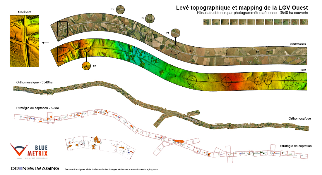
Service carried out on a 52 km section for the inventory and control of green spaces planted on the outskirts, on either side of the high-speed line: hedges, vegetated surfaces of embankments, young stands, shrubs, wooded areas, etc.

TECHNICAL INFORMATIONS

  • Aerial imagery processing service : Drones Imaging company.
  • Orthophoto : GSD 7cm.
  • Entire covered area : 3450ha.
  • Airborne platform : Avion.
  • Camera : Sony A7R.
  • Photogrammetry software : Metashape.
  • Use case taught in training : see more.
PrevPrécédentTraining in remote piloting applied to photogrammetry: facade inspection
SuivantTopographic survey and mapping by drone of the Maman Valentin dam (Guyana).Next
  • Mentions légales
  • Français
  • English