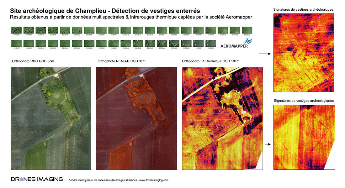
Archaeological detection by drone and thermal infrared.
Archaeological detection by drone: aerial study conducted on the old site of Champlieu (60).
RGB, NIR-G-B and Thermal Infrared images captation made on June 14, 2017 by Aeromapper with the S4 AVEM drone. Analysis and post-processing service by Drones Imaging.
Detection of archaeological remains by drone

The Gallo-Roman ruins of Champlieu are located in the department of Oise, in the commune of Orrouy. They correspond to the visible remains of an actual city which developed from the 1st to the 4th century AD. Today one can still see and visit freely the ruins of the monumental center of the small town. It consists of a theater of 71 m in diameter, a temple and thermal baths. The remains of the city are buried under the neighboring agricultural parcels.
In this context, and under the impetus of the Department of Archeology of the Oise (SDAO), the operation of Aeromapper’s AVEM drone and its three dedicated sensors (RGB, NIR-GB and thermal infrared) was to provide to archeologists an overview of the site, and to help in guiding and optimizing their research as well as completing the city’s maps.
Following the June 14, 2017 flight campaign and after images exploitation by the company Drones Imaging, thermal infrared photography immediately revealed linear photographic signatures that are characteristic of old buildings or ditches, which are invisible with RGB or NIR-GB datas. These images confirm the existence of already partially known urban planning elements and reveal other unknown elements.
Encouraged by these first discoveries, future drone operations are then envisaged before the end of the year to study the neighboring lands in similar conditions of hygrometry and temperatures. For the SDAO, these operations illustrate the important role of drones in scientific research and also highlight the performance of the AVEM drone for its endurance and multi-sensor carrying capacity.
TECHNICAL INFORMATIONS
- Aerial imagery post processing service : Drones Imaging company.
- Flights and aerial imagery captation : Aeromapper company.
- Spatial accuracy : centimeter.
- Orthophoto RGB and thermal : GSD 3cm and 18cm.
- Total area inspected : 35ha.
- Drone : AVEM.
- Range thermal camera : -1°C / 16°C.
- Photogrammetry software : Metashape.
- Use case taught in training : see more.
