Skip to content
Services et traitements des images aériennes
Twitter Facebook Linkedin
  • Français
  • English
DRONES IMAGING
  • Drones imaging
    • Who are we
  • images processing service
    • topographic service
    • thermographic service
    • agricultural service
    • automatic counting service
    • Use case
    • Product sheets
    • useful documentation
    • download guide
  • Trainings
    • training in photogrammetry metashape option
    • training in photogrammetry Pix4D option
    • Multispectral training
    • online photogrammetry training
  • Softwares
    • Agisoft Metashape photogrammetry software
    • Undet software
  • RTK Receivers
    • EMLID GNSS RTK Reach RS3
    • EMLID GNSS RTK Reach RS2+
    • Emlid GNSS RTK Reach RX
    • EMLID GNSS RTK Reach RS+
  • Sensors
    • Agrowing Multispectral cameras
  • News
  • Contact us
  • Toggle website search
Menu Close
  • Drones imaging
    • Who are we
  • images processing service
    • topographic service
    • thermographic service
    • agricultural service
    • automatic counting service
    • Use case
    • Product sheets
    • useful documentation
    • download guide
  • Trainings
    • training in photogrammetry metashape option
    • training in photogrammetry Pix4D option
    • Multispectral training
    • online photogrammetry training
  • Softwares
    • Agisoft Metashape photogrammetry software
    • Undet software
  • RTK Receivers
    • EMLID GNSS RTK Reach RS3
    • EMLID GNSS RTK Reach RS2+
    • Emlid GNSS RTK Reach RX
    • EMLID GNSS RTK Reach RS+
  • Sensors
    • Agrowing Multispectral cameras
  • News
  • Contact us
  • Toggle website search

Blog

  1. Home>
  2. geomatics>
  3. Topographic survey and mapping by drone of the Maman Valentin dam (Guyana).

Topographic survey and mapping by drone of the Maman Valentin dam (Guyana).

  • September 6, 2016
  • 1:05 pm

Banks surveying for erosion monitoring

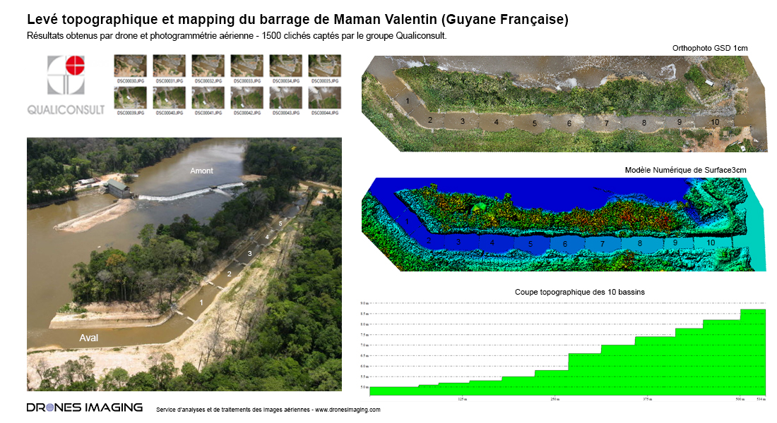
Banks surveying carried out by drone in French Guiana. Maman Valentin dam, July 2016: results obtained from 1460 aerial images taken by the Qualiconsult group, expert in diagnostics and technical inspections of constructions.

Topographic inspection of the banks

Banks surveying

Elevation map of the banks

Banks surveying

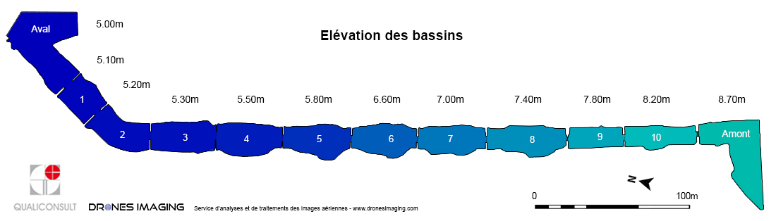
As illustrated above, orthophoto and digital surface model made it possible to build an elevation map of the 11 basins over a 500m length for a total of 3.7m drop. Subsequently and thanks to future flights with drone, this elevation map will serve as a reference to measure and monitor the erosion of the banks over time.

TECHNICAL INFORMATIONS

  • Geomatics and post processing service : Drones Imaging company.
  • Flights and aerial imagery : Qualiconsult Group.
  • Spatial accuracy : centimeter with GNSS RTK receiver.
  • Orthophoto RVB : GSD 1cm.
  • Covered area : 06ha.
  • Drone : Mikrokopter.
  • Camera : Sony A6000.
  • Photogrammetry software : Agisoft Metashape.
  • Use case taught in aerial photogrammetry training : see more.
PrevPrécédentTopographic survey and mapping of the Atlantic high-speed line.
SuivantPhotogrammetry & multi-color 3D printing of the Pic du midi d’OssauNext
  • Mentions légales
  • Français
  • English