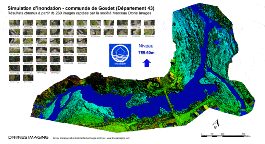
Flood simulation for DREAL geomatics August 22, 2017 Flood simulation for dreal (Regional Directorate for the Environment, Planning and Housing) Flood simulation carried out by aerial photogrammetry Continuer la lecture
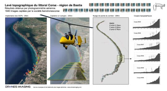
Topographic survey for coastal erosion monitoring geomatics August 18, 2017 Photogrammetry by gyroplane and topographic survey carried out for coastal erosion monitoring Photogrammetry by gyroplane: mapping and 3D modeling Continuer la lecture
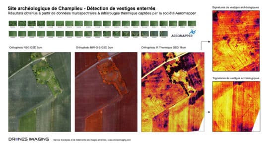
Archaeological detection by drone and thermal infrared. geomatics July 31, 2017 Archaeological detection by drone and thermal infrared. Archaeological detection by drone: aerial study conducted on the old site of Continuer la lecture
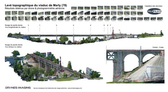
civil engineering structure – topographic survey of the... geomatics July 12, 2017 Building Information Model of the Marly viaduct made by drone and photogrammetry Building Information Model carried out as part Continuer la lecture
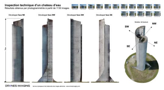
Inspection of a water tower by drone &... geomatics June 21, 2017 Drone inspection & cracks detection onto the walls of a water tower Drone inspection and photogrammetry: results obtained from Continuer la lecture
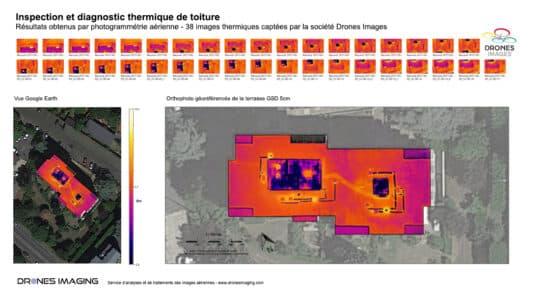
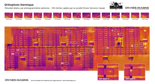
Roof thermal inspection and diagnostics by drone geomatics May 11, 2017 Roof energy audit carried out by drone Roof energy audit by thermal infrared aerial capture carried out on April Continuer la lecture
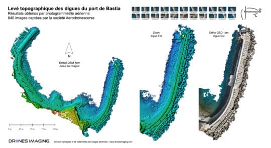
Topographic survey of the dykes at the Bastia... geomatics March 20, 2017 Dikes inspection by drone in the port of Bastia. Dikes inspection by drone: results obtained from 840 aerial images Continuer la lecture
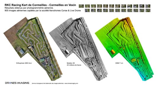
Mapping and topographic survey by drone – Cormeilles... geomatics February 17, 2017 Topographic analysis of the RKC karting circuit tracks Topographic analysis and Autocad plan made from DSM (Digital Surface Model) Continuer la lecture
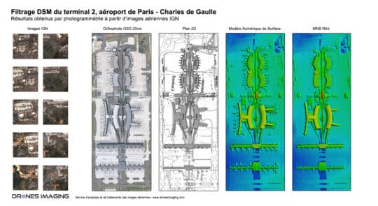
Open source 3D modeling – Paris Charles de... geomatics February 10, 2017 Open source 3D modeling of Paris Charles de Gaulle airport Open source 3D modeling of terminal 2: orthophoto, digital Continuer la lecture
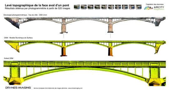
Bridge inspection by photogrammetry geomatics February 3, 2017 Bridge inspection carried out by aerial photogrammetry. Bridge inspection and 3D modeling of upstream/downstream faces. Results obtained from 520 Continuer la lecture
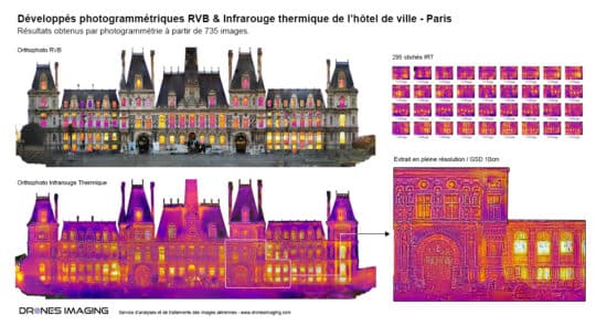
Thermal inspection by photogrammetry – Paris City Hall. geomatics December 16, 2016 Thermal orthophoto of the Paris town hall Thermal orthophoto of the west facade of the Paris town hall. Thermal and Continuer la lecture
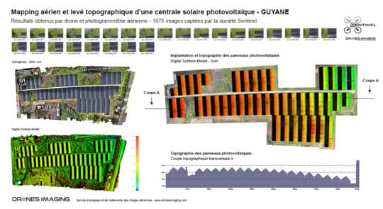
Aerial mapping and topographic survey of a photovoltaic... geomatics December 13, 2016 Topographical survey of a solar power plant in French Guyana Topographical survey of a solar power plant and visual Continuer la lecture
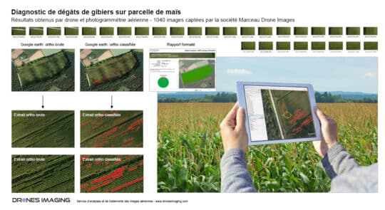
Game damage diagnosis carried out by drone geomatics November 23, 2016 Game damage mapping Game damage mapping carried out on a corn plot in Montargis. November 2016. Results obtained from Continuer la lecture
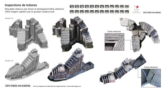
Drone roof inspections – Avoriaz geomatics November 17, 2016 Roof diagnosis by drone Roof diagnosis by drone, 3D modeling and mapping of 4 roofs on the Avoriaz ski Continuer la lecture
Photogrammetry applied to thermal imaging and solar panel... geomatics October 25, 2016 Solar panels inspection by drone Solar panels inspection from a thermal infrared orthophoto. October 2016. Result obtained from a Continuer la lecture
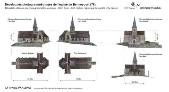
3D modeling by terrestrial photographic capture geomatics October 12, 2016 Terrestrial photogrammetry applied to BIM Terrestrial photogrammetry and digital twin of the church of Bennecourt. Topographic survey, October 2016: Continuer la lecture
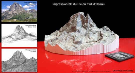
Photogrammetry & multi-color 3D printing of the Pic... geomatics September 19, 2016 Colorized 3D printing of the Pic du midi d’Ossau Photogrammetry and 3D printing of the Pic du midi d’Ossau. Continuer la lecture
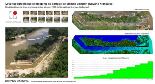
Topographic survey and mapping by drone of the... geomatics September 6, 2016 Banks surveying for erosion monitoring Banks surveying carried out by drone in French Guiana. Maman Valentin dam, July 2016: Continuer la lecture
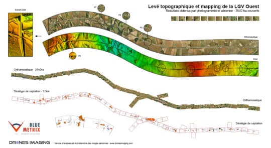
Topographic survey and mapping of the Atlantic high-speed... geomatics August 19, 2016 Aerial photogrammetry by plane – topographic survey of the Atlantic high-speed line Aerial photogrammetry by plane and topographic survey Continuer la lecture
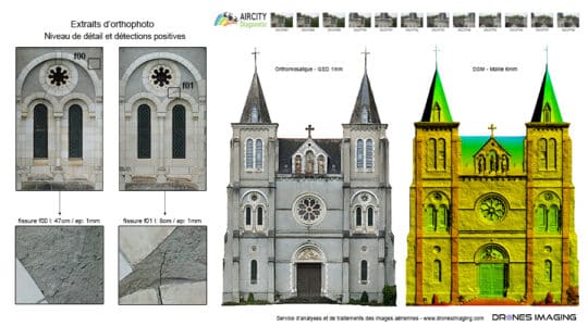
Training in remote piloting applied to photogrammetry: facade... geomatics July 24, 2016 Specialized training in remote piloting option photogrammetry. Specialized training in remote piloting: facade inspection exercise for a photogrammetric restitution. Continuer la lecture