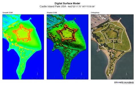
Topographic survey made from open source imagery. geomatics June 24, 2016 Open-source 3D modeling. Open-source 3D modeling: Topographic survey & 3D modeling of Castle Island made using satellite imagery from Continuer la lecture
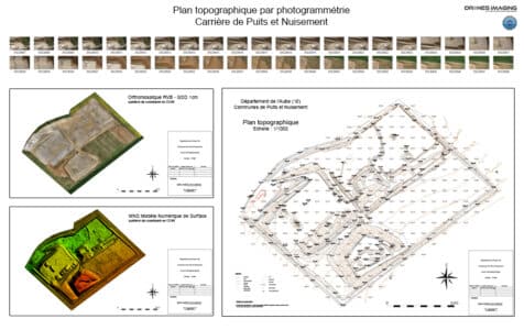
Survey plan and volumetric calculations produced by aerial... geomatics June 11, 2016 Survey plan and volumetry Survey plan and volumetry of the Puits et Nuisements quarry. Results obtained from 740 aerial Continuer la lecture
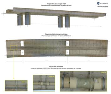
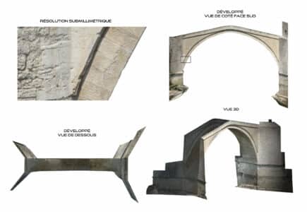
Engineering structure inspection by drone: deck intrados. geomatics May 27, 2016 Inspection of a deck intrados at the Careï viaduct Inspection of a deck intrados performed by drone and aerial Continuer la lecture
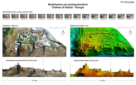
3D modeling by videogrammetry: Rabati Castle (Georgia). geomatics May 9, 2016 3D modeling by videogrammetry. 3D modeling by videogrammetry carried out on the Rabati castle for the protection of heritage. Continuer la lecture
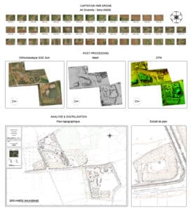
Topographical survey and quarry plan geomatics April 11, 2016 Regulatory topographic plan built by photogrammetry from aerial images. Regulatory topographic plan in Autocad format. Results obtained from 422 Continuer la lecture
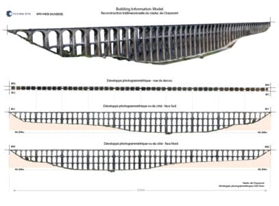
Building Information Model by terrestrial photogrammetry geomatics February 27, 2016 3D Modeling by terrestrial photogrammetry 3D Modeling by terrestrial photogrammetry: BIM (Building Information Model) of the Chaumont viaduct located Continuer la lecture
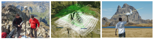
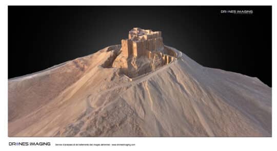
3D modeling of the Pic du Midi d’Ossau... geomatics December 23, 2015 3D modeling by photogrammetry of the Pic du midi d’Ossau. 3D modeling by photogrammetry of the Pic du midi Continuer la lecture
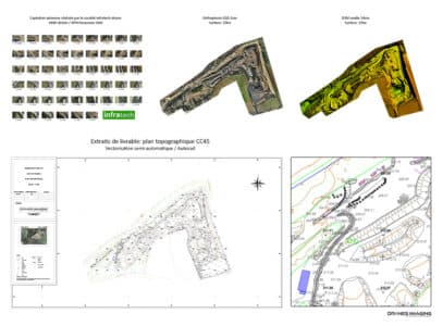
Topographic plans drawing service for mines and quarries geomatics December 1, 2015 regulatory survey plan for quarry management Regulatory survey plan: In order to respond to the mining industry markets, Drones Continuer la lecture
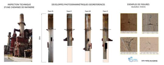
Technical inspection of a refinery performed by drone geomatics October 25, 2015 Inspection of a cracking tower and detection of disorders Inspection of a cracking tower: Photogrammetry views of the 4 Continuer la lecture
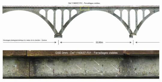
Engineering structure inspection by drone geomatics September 18, 2015 Inspection of the Jonction viaduct in Geneva Viaduct inspection: photogrammetric restitution of the downstream and upstream facings of the Continuer la lecture
Preservation of the cultural heritage of Palmyra –... geomatics June 11, 2015 Go back in time in Palmyra 3D Go back in time in 3D immersion around the castle of Palmyra. Continuer la lecture
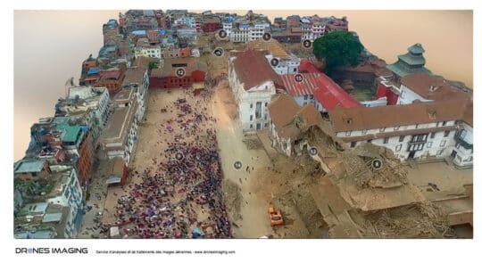
Earthquake in Nepal – 3D modeling of Basantapur... geomatics April 27, 2015 Earthquake in Nepal – 3D modeling of Durbar Square in Kathmandu Earthquake in Nepal, 3D modeling of downtown Kathmandu. Continuer la lecture
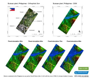
Bulacan, Philippines – a drone for study industrial... geomatics February 15, 2015 Flood risk prevention at a cement factory. Flood risk Prevention at the Holcim industrial site in the Philippines. Work Continuer la lecture
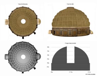
Terrestrial photogrammetry geomatics November 24, 2014 3D modeling of the Pantheon dome in Rome. 3D modeling of the Pantheon dome, masterpiece of Roman architecture. Work Continuer la lecture
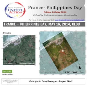
Ben4uav & Drones Imaging support the Philippines with... geomatics May 29, 2014 Drone and humanitarian aid in the Philippines for the benefit of the Croix Rouge Drone and humanitarian aid in Continuer la lecture
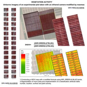
NDVI for estimating crop health and biomass geomatics March 30, 2014 NDVI Vegetation Index NDVI Vegetation Index: aerial images collection made on an experimental agricultural plot with a drone and Continuer la lecture
3D modeling and photogrammetric inspection of the Mostar... geomatics August 18, 2013 Mostar bridge inspection – Stari Most Bridge inspection: 3D modeling and orthofaces of the old Mostar bridge built with Continuer la lecture